GTACAD arises from the need to simplify and speed up the work done for the drafting of reports and projects of an Environmental Impact Study. Usually
prepared by specialized technicians without a specific familiarity with AutoCAD©, but maintaining the high quality standards to which the company has accustomed
its customers.
The main philosophy on which the program relies on the concept of a basic cartography that contains all the information from which derive a series of definitive
drawings that will constitute the impact study:
- Map of Existing and Planned Land Uses
- Map of Fauna and Habitat
- Map of Flora
- Map of Lanscape and Area Geography
- Map of Terrestrial Water Quality and Quantity
- Map of Noise
- Map of Air Quality
- Map of Terrain, Geology, and Soils
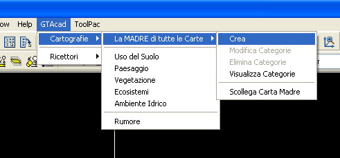
The program, developed in VBA and AutoLISP for AutoCAD© 2004, consists of several modules dedicated to the creation of the basic cartography, the modification of
the AutoCAD© graphic elements and the generation of the Derivative maps. The basic cartography is realized with standard AutoCAD© elements
on specific layers and must absolutely cover the whole area of the study.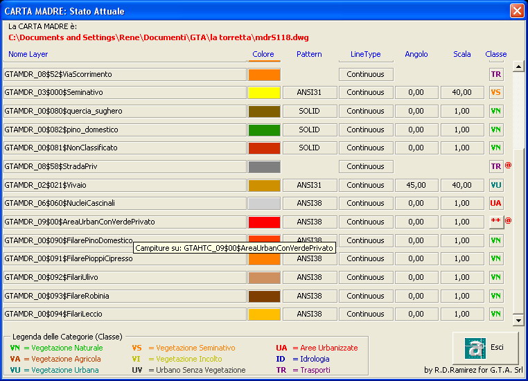
The construction of basic cartography is completely assisted allowing the technician (geologist, naturalist, chemist, environmental engineer, acoustic engineer, etc.), without
experience with the CAD environment, to draw a dwg file using only their specific knowledge for delimit the basic cartography. More often than not this operation is performed
on a dwg file, which as an external reference to another cartography, that could be an orthophoto or a raster file, so the operator only has to trace a path (polyline) or perimeter
the affected area (hatch pattern) by selecting the type of object from a pre-compiled interface which provides all possible classifications. The methods for tracking or selection
are customizable and it is also possible to insert blocks with information not visible in the drawing, but extrapolated in the derivation phase (eg: the number of floors of a sensible
building); furthermore it is possible, in case it is indispensable, to create non-standard objects that the program manages during processing.
 Of course it is possible to modify one or more objects by changing the type or class to which it belongs, as well as the graphic scale to adapt it to the final output (studies could
be written as reports in A4 format with attachments processed in variable formats even beyond A0 , or in reports in A3 format including the works). The functions of the GTACAD are
finally completed by a series of macros in Word© and Excel© for the controlled editing of the final report, as well as by programs that read the data
exported from the GTACAD and convert them into information that can be managed by other specific programs for pollution simulation, acoustic or chemical (SoundPLAN©).
Of course it is possible to modify one or more objects by changing the type or class to which it belongs, as well as the graphic scale to adapt it to the final output (studies could
be written as reports in A4 format with attachments processed in variable formats even beyond A0 , or in reports in A3 format including the works). The functions of the GTACAD are
finally completed by a series of macros in Word© and Excel© for the controlled editing of the final report, as well as by programs that read the data
exported from the GTACAD and convert them into information that can be managed by other specific programs for pollution simulation, acoustic or chemical (SoundPLAN©).
This was the first version of the GTACAD. The program has been adapted to the subsequent AutoCAD© platforms and expanded into functions, to become a first GIS prototype
in an Autodesk© environment.