-
What is it?
Inside the GTA srl the CAD program used is AutoCAD AutoCAD©, which has been extended through custom developed applications, in order to assist the design of the cartographic maps constituting an Environmental Impact Assessment, a Geological Study, a Construction Site Project, Acoustic Simulations, ..., etc. The main tool is the GTACAD, which is itself a container of tools that allow a more simple, quick realization of an EIA coherent with the graphic standards of the elaborations produced by GTA. With the help of this application it is possible, even for those who do not have a total mastery of AutoCAD©, to draw up complex documents through a assisted design procedure (wizard). This allows the technician to concentrate on the content of the document he is working on and to overlook the formal aspects of the final presentation of the project. The main philosophy of the program relies on the concept of a basic cartography, that is called CARTA MADRE (Mother of all the Maps), from which to derive a series of definitive maps: Maps of Existing and Planned Land Uses, Fauna and Habitat, Flora, Lanscape and Area Geography, Terrestrial Water Quality and Quantity, Noise, Air Quality, Terrain, Geology, and Soils, etc. The method relies on the CORINE LAND COVER project for the definition of environmental categories, to the AGI classification (Italian Geotechnical Association) and to internal classification for the acustic receivers type. All the specifications relating to these references are contained in external databases updated periodically, so it is possible to add specific entries outside the aforementioned databases, while the specific data of the individual project are part of the dwg file saved by AutoCAD©.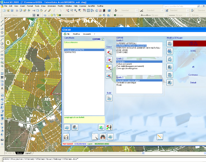 In addition to simplifying the process of drawing the maps, it is possible, through some specific functions, to obtain some reports related to the open drawing from the GTACAD, such as:
- the number of each type of block, the length of the polylines and the surface of the areas divided by each single layer;
- various types of reports relating to acoustic receptors, divided by type and with more or less information relating to the single receiver;
- the characteristics of the individual layers of the file.
From the drawings created with GTACAD, through specific exports, are obtained other files which are imported in simulation programs such as Sounplan© for noise modelling, MISKAM© for the atmospheric modelling, INM© for aeronautical noise, etc.
The program automatically recognizes the AutoCAD© files that have been generated through the use of this software and resets its own user interface to continue to operate on it, this means that if you are creating a Geological Map, only the items related to geology will appear, while if a specific Derivative Map is being opened, the options will only be those pertaining to the selected theme. The application must work and be installed inside the private LAN of the office, except for exceptions allowed by the Technical Management and works exclusively as an AutoCAD© plugin. -
The MOTHER Map and its daughters:
The MOTHER Map is the starting file that is created by the user by digitizing in a file that has as an external reference the basic cartography or an orthophoto, and represents the real state of the study area. The file thus obtained is not a file that normally goes to print, except for the possible need to draw up the card for a verification inspection, or for delivery to the client, and must completely cover the study area, even overlapping several different objects with distinct characteristics.The objects created by the program, which seen from a purely CAD point of view, are all polylinee, hatch (backgrounds) or blocks distributed on different layers in which only the description of the layer gives an idea of the content; but in addition to what is seen by the user these entities have additional information created by the GTACAD that interprets them and uses them in their own processing. The information is an integral part of the entities and inserted transparently internally to the dwg that does not require external files attached, this facilitates the management of the archives and the relationships with the customers.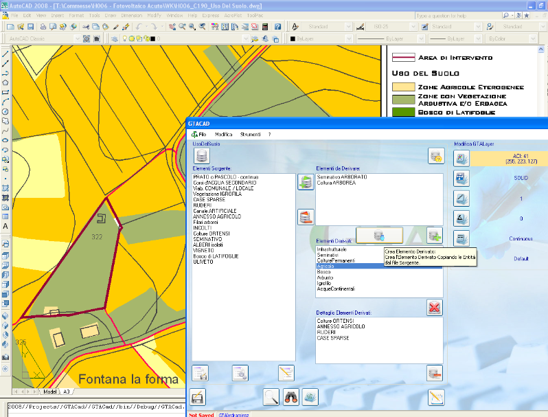 The same applies to the Geological Map, which is nothing more than a Mother Map specialized in soil and subsoil information. Through the appropriate options you can choose to manually
derive a Map, choosing the various items present in the Mother Map and arbitrarily combining them with the prefered descriptions, or, alternatively, choosinge to derive one or all the
map processed automatically; through this last option the program creates all the files with the CORINE definitions and the descriptions for the Key Legend that is part of the drawing
by itself.
The same applies to the Geological Map, which is nothing more than a Mother Map specialized in soil and subsoil information. Through the appropriate options you can choose to manually
derive a Map, choosing the various items present in the Mother Map and arbitrarily combining them with the prefered descriptions, or, alternatively, choosinge to derive one or all the
map processed automatically; through this last option the program creates all the files with the CORINE definitions and the descriptions for the Key Legend that is part of the drawing
by itself.
The data relating to the processing of the Derivative Map are exportable and reusable for a second derivation; this allows you to create daughter maps only once. If need is to make changes to the source Mother Map file, these data files can be used to automatically rebuild the specific daughter Map or all of them. As already mentioned, it is possible to obtain reports, in different formats, with the specific information of the daughter maps. These reports can be generated in the form of paper print, HTML files or ASCII type csv table files that can be imported into any spreadsheet for subsequent processing. In the case of reports for the calculation of lengths and surfaces, GTACAD also recognizes objects not created with the program and calculates them separately.
-
The GEOlogical MAP:
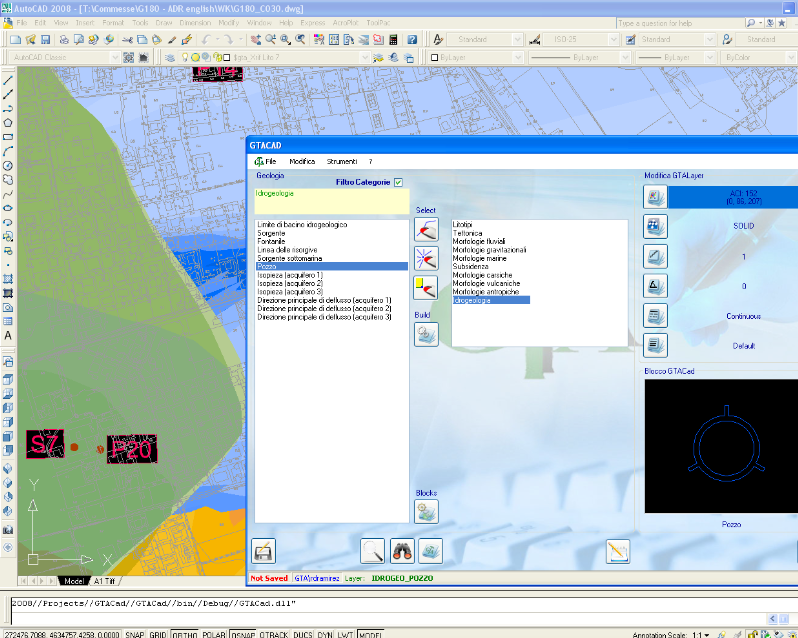 As previously anticipated, the Geological Map, which is created in the same way as the Mother Map and is a separate drawing, in which some derivative operations of the daughter maps,
such as the Water Environment Map, are combined with the Mother Map to integrate also the hydrogeological characteristics of the area of study. The graphical representation of the
Mother Map, the Geological Map and the daughter maps can be adapted directly by the operator according to his own needs and to the base cartography that remains an independent
file, this in order to be able to use either opaque bases, such as orthophotos or raster images, both transparent vector files; therefore the elaborations made with the GTACAD can be
overlayerd on the base or put underlayerd according to need.
As previously anticipated, the Geological Map, which is created in the same way as the Mother Map and is a separate drawing, in which some derivative operations of the daughter maps,
such as the Water Environment Map, are combined with the Mother Map to integrate also the hydrogeological characteristics of the area of study. The graphical representation of the
Mother Map, the Geological Map and the daughter maps can be adapted directly by the operator according to his own needs and to the base cartography that remains an independent
file, this in order to be able to use either opaque bases, such as orthophotos or raster images, both transparent vector files; therefore the elaborations made with the GTACAD can be
overlayerd on the base or put underlayerd according to need.
-
The Map of ACOUSTIC RECEPTORS:
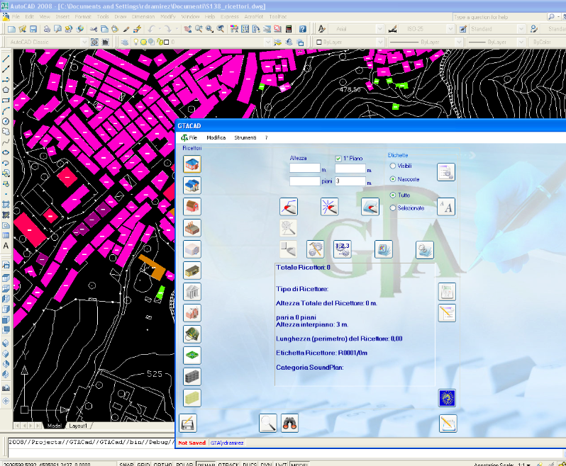 In addition to the aforementioned Mother Map and Geological Map, the GTACAD allows the creation of the Map of Receptors. This file, which is in itself a definitive paper for some projects
(acoustic studies, vibrations, pollution), derives from a census of the receivers and allows the creation of four types of specific reports. It is possible to number and specify the
characteristics of each receiver, such as the type (Sensible, School, Residential, Production, Industrial, etc.), the total height and the individual floors and the presence of acoustically
important objects such as walls or sound-absorbing or reflective barriers. It is possible to find a specific receiver through its own identifier and calculate how many receptors exist for
each specific type. During the preparation of the Map of Receptors, each receiver is also assigned the necessary parameters for acoustic simulations, which are not visible to the operator
but are used by the SoundPLAN©.
In addition to the aforementioned Mother Map and Geological Map, the GTACAD allows the creation of the Map of Receptors. This file, which is in itself a definitive paper for some projects
(acoustic studies, vibrations, pollution), derives from a census of the receivers and allows the creation of four types of specific reports. It is possible to number and specify the
characteristics of each receiver, such as the type (Sensible, School, Residential, Production, Industrial, etc.), the total height and the individual floors and the presence of acoustically
important objects such as walls or sound-absorbing or reflective barriers. It is possible to find a specific receiver through its own identifier and calculate how many receptors exist for
each specific type. During the preparation of the Map of Receptors, each receiver is also assigned the necessary parameters for acoustic simulations, which are not visible to the operator
but are used by the SoundPLAN©.
The interface has two levels, for more or less experienced operators, and allows the modification even in successive phases of several receivers simultaneously. From this map two files can be exported for the simulation programs, a dxf and an ASCII csv file which are imported by SoundPLAN© for their own calcuations. Moreover, from this file, together with the Geological Map, we obtain the Vibration Map. It is possible, at the end of processing, to generate for each type of receiver, a different representation based on the height ranges, which can also be defined by the user individually for each type. The set of basic maps, Mother Map and Geological Map, allows to best discretion the acoustic simulations through the Noise Map, which has no meaning for the customer but assigns to the objects characteristics of reflection or sound absorption and vibrations, so for example an average evergreen forest 6 meters high takes part in the simulation as an absorbent surface and reduces the noise perceived by nearby receptors.