 In order to keep the GTACAD updated with the latest release of AutoCAD©, for the development of the latest version we aimed to increase the operational freedom of
the technician.
In order to keep the GTACAD updated with the latest release of AutoCAD©, for the development of the latest version we aimed to increase the operational freedom of
the technician.
While maintaining the basic philosophical approach of the program, therefore to support the technician not expert in the use of AutoCAD©, this version of the program
allows to pass from one drawing to another without the need to close and re-launch the main GUI. When the drawing is changed, the program recognizes which type of file (Mother
Map, Derivative Map, Geological Map, Map of Acoustic Receptors) is active in the AutoCAD© editor; if the drawing was made with the GTACAD
specifications (any release), and changes its interface accordingly, providing the user with the specific tools for that type of drawing. If the file is not a GTACAD file, it 's
still possible to use the drawing and calculation tools of the application limited to AutoCAD© entity objects. References to the
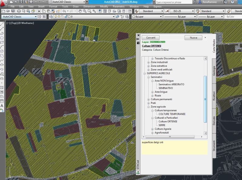
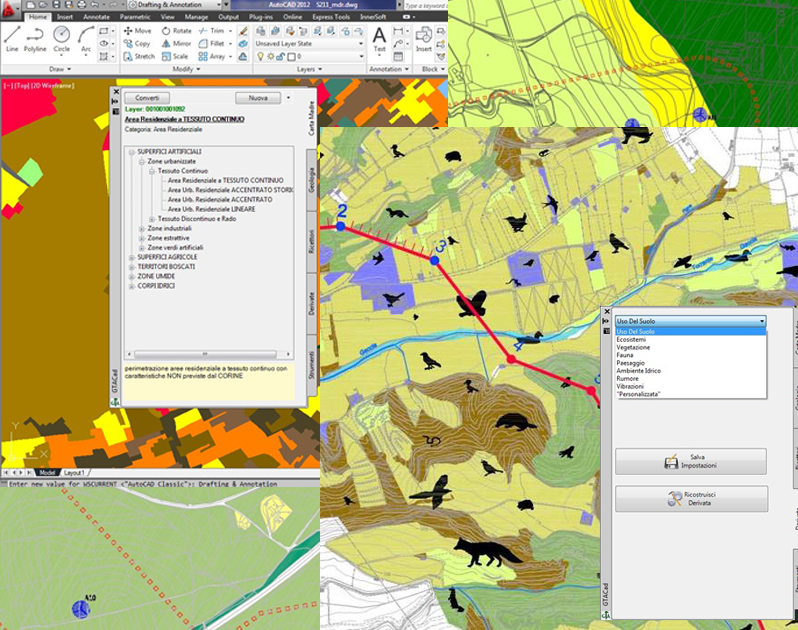
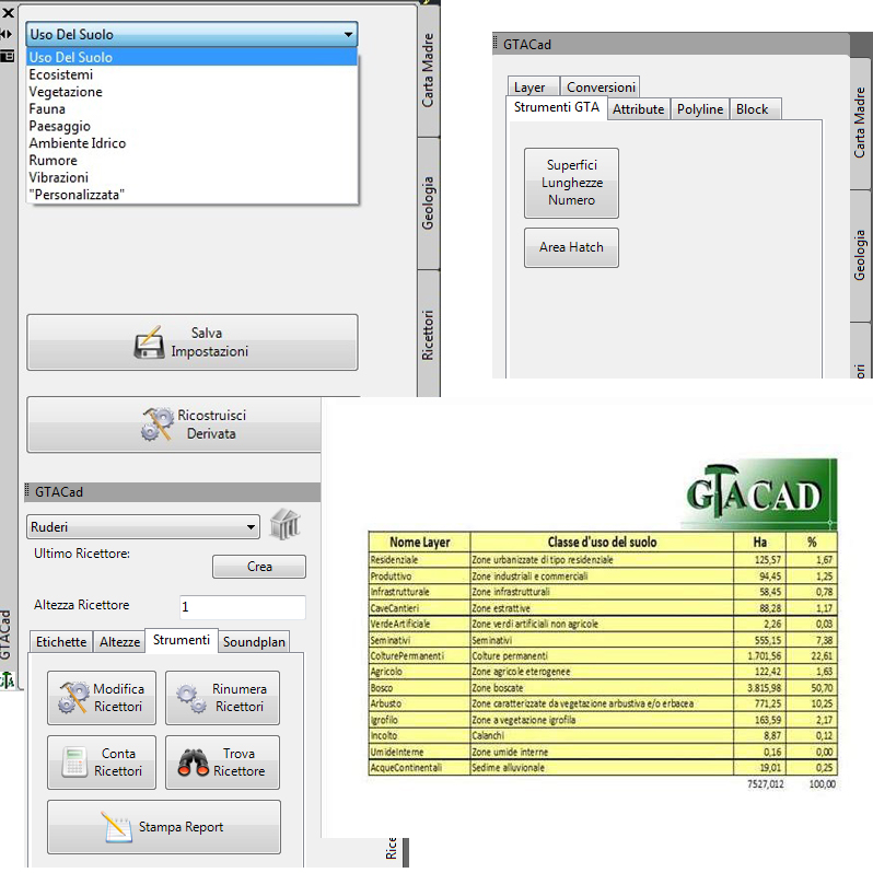
CORINE LAND COVER are always available in the tools palette, which is now floating and re-sizable, also displaying
which will be the destination layer of the graphic entities and the graphic characteristics of the objects therein. The specifications of the CORINE are now saved in the entities
themselves and are independent of the layer in which they are stored, so a file sent to a customer is seen as a common dwg, but interpreted by the GTACAD with a series of
additional information. Unlike previous versions, it is no longer necessary to redraw roads, perimeters and borders of the areas concerned, but now it is possible to directly import
the objects already present in the base map, making the work of creating the Mother Map more simpler and faster, the program takes care of replacing non-exportable objects in
simulation software with basic AutoCAD entities that can be read by the SoundPLAN© or by the INM© (Integrated Noise Model) of the Federal Aviation
Administration for example. In the rewriting of the program, the GTACAD was also detached from system files and external databases; this latest release contains all the information
inside it and can be updated even without actually installing it.
 This new type of approach allows, in addition to the previous ones, also the following options:
- Use of the GTACAD generic tools even with non-owned files and drawings, so it is possible to use the tools on the block attributes or export the various reports relating to graphic entities, areas, blocks, polylinee, etc. even on common AutoCAD© files;
- The derivation and reconstruction operations of the derived maps such as Existing and Planned Land Uses, Lanscape and Area Geography, Fauna and Habitat, Terrestrial Water Quality and Quantity, Terrain, Geology, and Soils, etc. are more streamlined and faster and it is also possible to combine the maps together in order to retrieve more information in the creation of the various reports;
- Automatic generation of the legend and title blocks;
- The ability to change the attributes of the title blocks on multiple drawings at the same time without the need to open all the related files unless they are being printed. This last option has proved to be very useful in cases where the background is a very heavy aerial photogrammetry;
- New road and rail tracking tools have been implemented that allow to obtain an axis and the related 3D embankments borders, as well as to build, using the Delauney triagulation algorithm, a simulation of the existing terrain, that combined with these elements returns excavations and embankments.
Particular attention was paid in improving the exchange of files with the end customer's specifications, so the conversion of colors and thicknesses of lines is automatic, one must only load the target ctb file to convert the GTACAD ctb to the customer's. Similarly it is possible to replace the backgrounds (hatch) and the ACAD linetypes with those of the customer. This allows to draw up a project with different specifications from those adopted internally and to integrate only some components in a study done in collaboration with other companies. In this version it is possible to print on paper, with the relative legend, also a draft of the "Mother Map", useful to check on the spot what deducted from the initial photointerpretation.
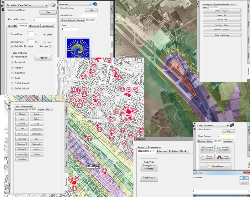
NEW IMPLEMENTATIONS FOR ACOUSTIC STUDIES:
The specific instruments for acoustic studies have been completely rewritten to adapt the GTACAD to both the new AutoCAD version and the new SoundPLAN© and INM©
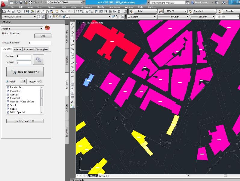
versions. In addition to all the old possibilities, the number of creatable receptors was virtually infinite, the previous limit was 9999 units, and the continuous control over the
total of the receivers was removed which slowed down the initial creation phase when the number of receptors reached a few thousand entities. In this version the receivers are created
independently of the existing ones and reorganized only during the export phase, maintaining the possibility of rearranging them at will by type. This allows the multiple technician
to draw the map of the receptors at the concurrently and to assemble the various parts at a later time before sending the whole map to the simulation program. In this version it is also
possible to find a receiver in a drawing among thousands immediately and modify several receivers simultaneously based on one or more common properties, as well as highlighting only
the receivers with a specific particularity selected by the operator.
 The whole part related to the creation of receptors and noise sources has been revised so as to allow a more expert technician to insert specific acoustic characteristics such as noise values on
the façade, the latter can also be modified at a later time both individually that in groups, even by a user not specialized in acoustics, according to the directives of those
who will make the simulation materially. Again with a view to making the drafting of drawings simpler, a system for importing the simulation results into a common dwg file was created
in order to be able to give the final customer a partially editable work with elementary AutoCAD entities such as polylinee and hatches with transparency to be superimposed on an aerial
photo. Using the GTACAD with the Autodesk 3D MAP© or with Autodesk CIVIL 3D©, and thus exploiting the GIS potential of these Autodesk applications, it is
now possible to export the results also on Microsoft Bing Maps©.
Below two simulation excerpts created by SaoundPLAN© with the help of GTACAD:
The whole part related to the creation of receptors and noise sources has been revised so as to allow a more expert technician to insert specific acoustic characteristics such as noise values on
the façade, the latter can also be modified at a later time both individually that in groups, even by a user not specialized in acoustics, according to the directives of those
who will make the simulation materially. Again with a view to making the drafting of drawings simpler, a system for importing the simulation results into a common dwg file was created
in order to be able to give the final customer a partially editable work with elementary AutoCAD entities such as polylinee and hatches with transparency to be superimposed on an aerial
photo. Using the GTACAD with the Autodesk 3D MAP© or with Autodesk CIVIL 3D©, and thus exploiting the GIS potential of these Autodesk applications, it is
now possible to export the results also on Microsoft Bing Maps©.
Below two simulation excerpts created by SaoundPLAN© with the help of GTACAD:
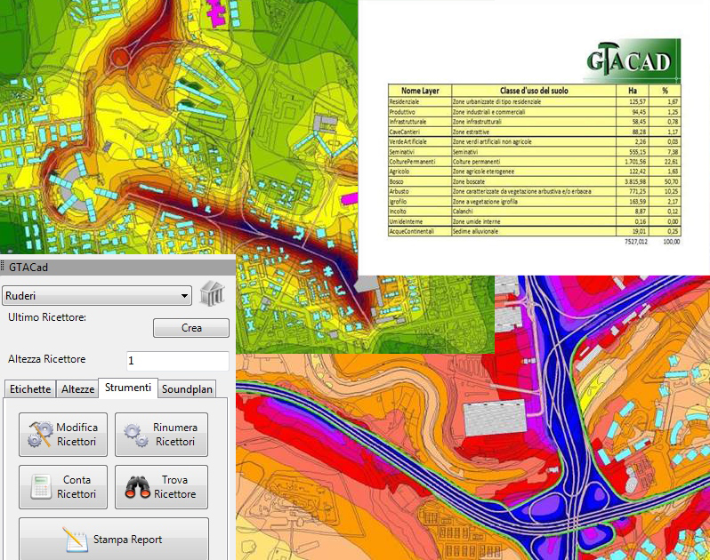 Two airport simulation excerpts created by the INM© with the help of the GTACAD: